OVERVIEW
The Press Expedition Traverse is the modern-day trail version of a path blazed in the late 19th century by a group of seasoned wilderness veterans which included the first “civilized men” to see the interior of what is now known as Olympic National Park (ONP.) Funded by Seattle Press, a newspaper which leveraged its entire wealth into this single story, the expedition would enter from the northern Elwah River Valley area in the fall of 1889 and find their way over-mountain and under-branch to the Quinault River Valley area, returning to civilization in the late spring of 1890.
James Halbold Christie, a seasoned frontiersman in the spirit of Ron Glass and Daniel Boone, led the group and provided the skillsets needed to survive the harsh conditions of Olympic winter. Mount Christie is named after this heroic figure and can be seen during this hike along with numerous other peaks.
Nowadays the P.E. Trail is the combination of two separate ONP trails which meet in the lower central ONP: Elwah-to-Low Divide (28mi/45km from the north) and North Fork-to-Low Divide (16mi/25.7km from the south.) Do not let the name “North Fork” confuse you – it is on the south side of the Park but is the northern fork of the Quinault River. In addition, there is another “North Fork” trail near Sol Duc.

While this hike adds up to 44mi/71km within the ONP, you must cover 50mi/80km to complete this traverse which roughly bisects the Park longitudinally. The removal of the Elwah Dam, effected by congress in 2011 to save the endangered Salmon population, led to the eventual severance of Olympic Hot Springs Road which previously connected the Elwah Trailhead to Hwy 101. Now you can only get as close as Madison Falls Trailhead, a 6mi/9km hike from the Elwah Trailhead using a long road and a 500yd bypass trail which allows hikers to access the north-central areas of the park.
PREPARATION
Planned Hiking Dates: July 16-22, 2020 (7 days)
The 2020 COVID pandemic offered difficulties in planning, with the backcountry sites finally reopening on July 1, just weeks before our departure despite our having anticipated the hike for many months.
Though I was not a highly experienced backpacker, I had researched the trip as best I could and would lead my group of four into the unknown. As trail maintenance had been mostly suspended since the winter storms, recon on the trail conditions was thin at best.
OUR PARTY
We each purchased a significant amount of new gear for this hike and ended up with packs heavier than they needed to be. By the end of the trip we each knew how to shave off at least five pounds for the next expedition.
- STEVE (me): 47 yrs old, enjoy hiking and backpacking but would not call myself “avid” at either
- AUNDRE: Turned 36 on this hike, veteran day-hiker, strong backpacking/wilderness experience
- CHRIS: 31, Backpacking rookie with minor day-hiking experience, using all new gear
- MITCH: 30, Late addition to the team, backpacking and hiking rookie with brand new unbroken shoes! Poor kid had no idea what he was getting into but comported himself remarkably well
PRE-HIKE
We camped at Fairholme on Crescent Lake for two days prior to the hike, providing a soft transition from city to wilderness. Everyone got familiar with setting up their new tents, packing/unpacking their tents, sleeping bags, packs, etc. I made a hurried assessment that we had brought not nearly enough food and ended up adding 16-20 additional MRE’s to our supplies. This proved to be an error; I should have added no more than 6-8. Every three MRE’s equals approximately one pound, they do not pack snugly, and you must pack out the empty pouches.
DAY 1, MORNING
Madison Falls Trailhead
to North Fork Trailhead by Shuttle

We packed up the car Thursday morning and drove 25 minutes to Madison Falls Trailhead. Here we met Jenny, our Olympic Hiking Co. shuttle driver. This company provides guided hiking tours around the peninsula and offers custom shuttles such as ours, a three-hour drive from the western Port Angeles area to Lake Quinault. The price was $350, and they were very flexible on the pickup time as it was their only such shuttle of the day. This drive passes through the town of Forks, forever the haven of Twilight fans the world around. Further south is Kalaloch, a popular set of campgrounds on bluffs overlooking the Pacific. After this, cell service deteriorates then falls off completely as you enter the Lake Quinault area.
DAY 1, AFTERNOON
North Fork Trailhead
to Trapper Shelter
Dist: 8.1mi/13.0km
Net Elevation: 680ft/207m
We arrived before noon as hoped, bid our driver farewell, then spent the next 30 minutes with packing adjustments to account for the added foodstuffs. I then realized that North Fork Trailhead and North Fork Campground are not one and the same. Now our walking journey began with a 330yd/300m hike from the campsite area to the trailhead area, where we were surprised to see many parked cars. Some of these belonged to day hikers, others to groups that were going up to Low Divide for a day or two then returning to North Fork.
My goal was to hammer out the first 12.2 miles in one day, ending the first leg at Sixteen Mile camp (it is 16 miles from somewhere in Lake Quinault, but not the trailhead,) an elevation gain of 1400 feet. This too was a mistake, as I had overestimated our hiking speed on the day. At best we would have made it there around nightfall and would have needed to ford the Quinault River in near darkness. For future hikers of this trail, I suggest leaving by 9am from the trailhead.

North Fork Quinault Trailhead. Alt 520 ft. Left to Right: Steve, Mitch, Aundre, Chris
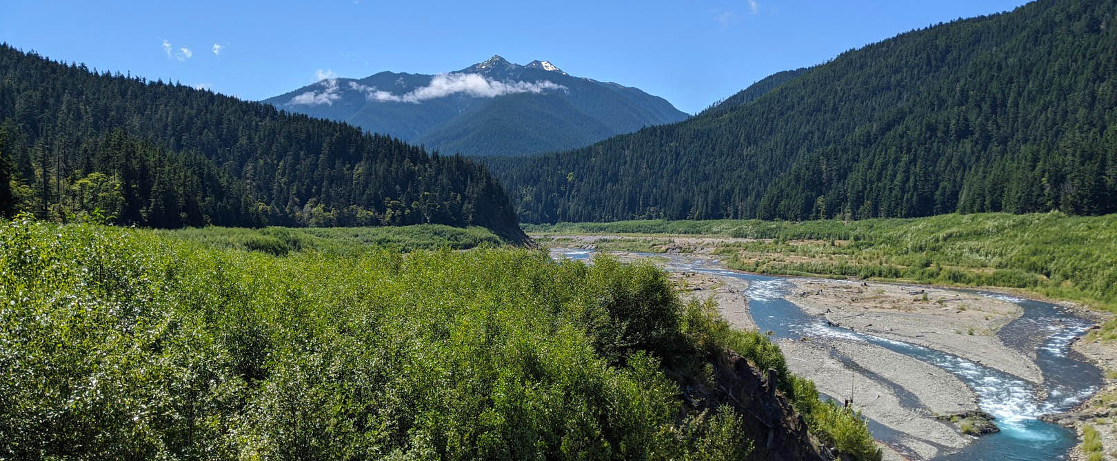
The North Fork Quinault Trail begins as do many other hikes in the ONP, especially on the western half which is primarily temperate rainforest, an oddity in North America and around the globe. The clear path ascended slowly though standard topography and vegetation; we encountered no surprises. The seven-day forecast promised lots of sun and temperatures in the 80’s, a change from what had been a cool summer in Western Washington to this point. We would be thankful for the shade provided by the heavy tree coverage throughout the week.

Near the mouth of the Quinault River


Common views on Day 1

First major fork
WOLF BAR CAMP
Our first break was at Wolf Bar, 2.5 miles into the hike with 110 feet of elevation gain. This is a small camping area with water access and only one or two primitive sites with fire rings (that we saw.) Nice spot for a day hike and picnic. No privy here that I recall.
Around 5:20pm we came to the Elip Creek campsites, having gained 6.5mi/10.4k in distance and 500ft/152m in altitude. With good water access here (again, no privy that I saw,) we stopped for “lunch” not knowing that this was in fact dinner, nor that we were badly behind schedule. We took nearly a two-hour break, setting up our stoves and cooking up MRE’s for the first time. We rested, reloaded on water, and got going again around 7:15. With 3 hours of daylight remaining, it still appeared quite bright outside and I was not yet concerned about having time to set up our final camp of the evening.

Nice site at Elip Creek, on ascent back to trail. Alt 1060 ft.

The trail ascends sharply out of the camp’s rear, and the real upward journey into the park begins. At the top of the hill is the first major path fork on this journey. I will take a moment here to explain a couple of things about an alternative hike out of North Fork. The sign here points left to the Skyline trail, a 20-mile path that parallels the North Fork Quinault Trail several miles to the west, creating a large loop with Low Divide at the north end. The 4.6-mile trail indicated here is known as the Elip Creek Trail, creating a smaller loop in the lower third of the larger 36-mile loop.
I understand that bear line is a difficulty on the Skyline Trail and that bear canisters are required, two reasons we chose the hiking path we did.
Continuing north on our trail, it is 2 miles to the next waypoint at Trapper Shelter, and nearly 6 miles and 1000 feet of elevation gain to Sixteen Mile Camp.
The trail along this segment is pretty much the same, though we finally encountered our first significant tree-fall across the path here. This would become a trend for the next several days at we entered the deeper areas of the ONP.

First of many obstacles to come
As we approached Trapper around 8pm, I knew we were going call this waypoint home for the night. If you wonder why I keep calling this a waypoint, you are about to find out. Unfortunately we became too busy to take any photos of the upcoming ordeal.
I knew Trapper Shelter had a physical wooden shelter and little else in the way of accommodations, and had hence not planned on staying here. When I caught sight of the shelter, my heart sank: it was occupied. While it is always nice seeing people on the trail, Trapper is tight on space, and a group of six hikers ahead of us had claimed it for the night. Behind the shelter, which has five hard wooden bunks directly off the main path, is one small campsite with a fire ring and an uncovered privy about 30 yards south.
We were forced to stomp out a very tight area uncomfortably close to the privy as darkness and bugs descended, while the temperature and humidity remained high and muggy. With no designated bear line structure, we resorted to paracord and spend the next 90 minutes trying to find decent locations to hang our abundance of food bags. By the end of it all we were soaked in sweat, disheartened by the sour turn of events, and thoroughly exhausted. With food stored we skipped dinner and got to sleep as fast as we could.
The heavy packs, late departure, and nearly 2-hour lunch break at Elip combined to put us behind schedule for several days. As stated earlier, it is highly inadvisable to reach Sixteen Mile camp at dark, as the only major Quinault River crossing lies directly before the campsite. The depth and power of the river is variable and predictably very strong in the spring. Though we would face only a moderate knee-deep crossing the next day, it is suggested you only ever do this in full daylight. This is doubly true now when Ranger Stations remain unmanned and help is even further away than usual. Camping on the river’s southern rocky bank is not viable.
DAY 2, MORNING
Trapper Shelter to Sixteen Mile
Dist: 4.1mi/6.6km
Net Elev: 800ft/244m
I arose at 9:00am and quickly retrieved the food sacks, anxious to see they had not fallen and/or been raided by wildlife. All was well. As the other group had departed, we ate a hurried breakfast in the shelter and got moving at 11am, once again later than we should have departed, given we were four miles behind on the planned route and now facing a long uphill climb. Though it was another warm day and we occasionally lost the cover of the canopy, the altitude gain brought cool winds and different views rising out of the rainforest.

Looking East, probably Mount Lawson rising up to the right
As you may have seen from the original sign at the trailhead, there is supposedly a “Twelve Mile” camp just a mile short of Sixteen Mile camp. We believe we walked through the remains of this camp but never saw a sign for it nor any side trails.
We saw the most “other hikers” on this day. I spoke to an older gentleman who was running our same hike in reverse, from Elwah to Quinault. His pack was significantly lighter than my own; we were likely making the run in just three to four days and a very light hiker.
In the early afternoon we reached the Quinault River crossing just short of Sixteen Mile camp. Still carrying 95% of the weight we started with, we were hard spent by lunchtime. The river crossing was easy enough – we all swapped out for water shoes, crossed over, then pulled out the stoves for lunch. I had my first Mountain House Lasagna MRE – not bad! We also had to bust out the first aid kit and start tending early minor wounds which included blisters and basic leg/arm lacerations from rough foliage. At times it was tough to see the edge of the trail and I slipped to one knee a couple of times, lucky not to sustain any sprains or strains.
DAY 2, AFTERNOON
Sixteen Mile to Low Divide
Dist: 4.0mi/6.4km
Net Elev: 1600ft/488m
I had originally planned to hike all the way to Chicago Camp, nearly two miles past Low Divide, but made this decision based on bad intelligence. Those two miles run down a very steep set of switchbacks and I would not recommend attempting that segment late in the day with backpacks. Low Divide is a very worthy destination and the main goal of many backpackers entering at North Fork.
Our next segment brought changes. The trail rises high above the river to the point that you can hear it but rarely see it. I don’t recall any major treefalls, but we did see more gravel-face crosses such as the one pictured here, probably caused by a rockslide. Some of these footpaths were quite narrow with long treacherous downhill slides a distinct possibility if a hiker were to lose focus and footing.

Mitch looks on as Chris says, “We’re good here,” but this was not always the case
We all consider this to have been the toughest day based sheerly on the elevation gain, distance, and pack weight. The next day would offer new challenges but for now all we saw was the constant rise of the trail with very few flat breaks. The trail was undoubtably beautiful but also monotonous, requiring frequent short breather breaks and occasional pack-off stops of five minutes or more. The ridgeline climb offered very little variety in the scenery until the final stage as we gained the mountain pass.


Left – A high bridge crossing. Right – Very large leaves up here.
While I purchased this Google Pixel 4XL specifically for its photo capabilities, it also served to keep me sane on this arduous day as I audiobooked my way through the pain. Listening to The Dark Tower, Stephen King’s seventh book of the long series, I kept my mind apart from my aching arches and lower back.
The trail finally gives up on its relentless switchbacks, levels out, and exits the forest. At this point you’ll notice the vegetation has changed quite a bit since the rainforest origins of the hike. The air is much drier and cooler, as are the evenings. Our morale spiked when at last we entered the fabled meadows I had guaranteed as the
payday for this grueling ascent. Forgotten were our screaming swollen feet and broken bodies; the highest altitude of the traverse lay right before us, and only at the end of Day 2.
Without question, the vistas of Low Divide lived up to their reputation. I’ll let the next few photos speak for themselves. They begin on the final ascent into the pass.

First mountain meadow

Mount Seattle

The ridge declines to its lowest here to create a gorgeous mountain pass, hence the name Low Divide


A modest trail meanders through the evening mountain meadow


Clockwise from upper left: Mt Christie, Low Divide Ranger Station, Communal fire ring, Trail continues
Low Divide continued to impress as we found an awesome communal area, clean privy, easy-access bear line, and a choice of any tent site in camp! The Ranger Station was unmanned as expected. As it was Aundre’s birthday, we immediately got to building a fire and starting some festivities including a well-earned dinner and plenty of tea with some splashes of bourbon to warm our bellies and soothe our aching bodies. Two camped in the open meadow (bottom-right photo above) while Mitch and I found a great site under the trees back behind the bear line, providing lovely shade and cool air in the morning.
Ramen noodles were quickly becoming a go-to end-of-hike meal for me; they prepped in about 5 minutes and quickly replenished water, salt, and carbs. Personally, I am going to start preparing my own dry mixes to pack in and provide a wide variety of flavors in healthy hydrating trail soups!
We celebrated this key milestone of the hike into a gorgeous and near pitch-black Friday night just 48 hours before the new moon. In fact, we never saw the moon once in seven days, making it easy to see the expansive Milky Way in the clear mountain sky. Satellites and meteorites abounded. By the next morning we would all feel well refreshed, restored, and ready for the next leg.
In the winter of 1889-1990, the Expedition camped here, subsisting on base provisions which mainly consisted of flour and water, aka “Flour Soup.” Eventually they encountered bear and elk in hectic chases which resulted in the death of a hunting dog, but the fresh provisions restored the team, boosted morale, and set the stage for their final descent into the Quinault River Valley.
Low Divide is an awesome place to camp, but you must backtrack about 200yds to find the nearest easy water source. There are no camp-side rivers at this altitude. We could hear rushing water not far away, but it was through some very thick brush.
DAY 3, MORNING
Low Divide to Chicago Camp
Dist: 2mi/3.2km
Net Elev: -1415ft/-431m
In the morning I backtracked for water and took more pictures of the meadow and Mt Seattle in very different light, as you can see from the photos below. I pumped our water for the day, returned to camp, and we got going around noon. It was not likely we would reach Hayes River camp by the end of the day as originally planned, and we had no idea what obstacles lay beyond in the center of Olympic National Park.


Returning to the mountain meadows for morning light – here I would see history in the making (see End Notes)
The final half-mile of Low Divide moves back into higher brush, then forest, then begins a steep switchback descent of the high ridge. Along the way we passed gorgeous Lake Mary and a few other worthwhile vistas.

Lake Mary
Here you are never closer to Mount Olympus along this trail, at 8mi/12.8km to the Park’s titular center. Below, I want to believe we have our first glimpse at the 7700ft/2346m peak in the left third of the frame. Mt Queets and Mt Meany would be in the center, with Mt Wilder rising to the right, peak not shown (all unverified.)

Looking northeast, we may have a rare glimpse at Olympus from great distance.
This next stage of the hike was interesting. I warned the guys that downhills are generally more dangerous when it comes to backpacking injuries. The untended trail conditions only added to the potential trouble.
You may have noticed in an early photo that I was wearing gloves (batting gloves specifically.) I am very protective of my hands and already had a few nasty fingertip cuts that were nagging on a regular basis. When moving into uncertain heavily wooded areas, I strongly recommend hand protection. Work gloves are OK, but batting gloves are fitted and provide a strong leathery layer on the palm-side where it counts in hiking. Forest surfaces cover the entire range of dry, wet, rough, squishy, hot, and cold, not to mention the unexpected. It is virtually impossible to rip off a fingernail while wearing gloves. Little injuries to the hands can add up, making it more difficult to perform simple operations like pumping water, tying knots, and rolling sleeping bags.
In the first two days we had followed the Quinault upriver to its source, now we followed the Elwah downriver from its glacial headwaters. This was another warm day, requiring focus. The trail was frequently overgrown but we were unlikely to lose it if we simply kept laying one foot down in front of the other. The treefalls were the real challenge and served to once again thwart the hiking speed I had expected on the day.
Just before Chicago Camp, around 2:45pm (2.5 hours of hiking with a 1400ft/426m elevation drop,) we reached a very large log bridging the Elwah River and leading into the campsites.

Aundre takes the bridge provided by Mother Nature

The Elwah is shallow here, but not worth taking your shoes off if you can help it
DAY 3, AFTERNOON
Chicago Camp to Camp Wilder
Dist: 4.9mi/7.9km
Net Elev: -300ft/-91m
Chicago Camp (2185ft/665m) appeared as though hit by WWII mortar fire. A winter storm apparently flattened the area and I would be very impressed if teams manage to clear it out before the next winter comes – I’ll explain why later. Large trees were blasted to bits and it was difficult to locate the exit trail, privy, or any campsites not positioned on the river (there were two nice ones near our entry point.) Otherwise, the camp has obvious convenient access to cool mountain water from the Elwah and made for a great lunch spot. The bear wire area was intact.

Winter storms in the ONP are fierce and devastating

Theme of the day
From here the trail flows west/northwest and FINALLY flattens out (more or less,) with only a 300 foot drop over the five-mile run. However this day wasn’t finished with us. This path threw many obstacles at us; every time we got some momentum going, we were stopping yet again to change our shoes, cross a makeshift bridge, dance across rocks in a low stream, or look for alternative ways over questionable/dangerous terrain.
This culminated in a hair-raising log-shimmy over a deep rushing segment or offshoot of the Elwah, with true disaster looming in the event one of us were to fall in.


Hard day, but if you don’t stop to look now and again, what’s the point? Douglas Fir fans will love this leg of the journey.
Later in the evening I would compare this hike to a round of Mario Bros., Pitfall, and Prince of Persia rolled into one – it was one random daredevil obstacle after the next.
We finally found ourselves back in more manicured areas when we saw recently (we think) chainsaw-cut logs for the first time since before Low Divide. The trail was clear for the final approach to Camp Wilder, branching left off the main trail into many acres of tamed forest.
We explored Wilder to find a wooden shelter much like the one at Trapper, an uncovered privy, bear line structure, and an awesome campsite across a small brook. By now we realized the theme of the trip: at lunch we always had easy access to a rushing river for water, but at dinner we were always 100yds or more from some murky stream, and Wilder and was no different. With easy access to wood, and the entire camp once again to ourselves, we enjoyed the site a great deal, but longed just for ONCE to have some water right by the camp, for no other reason than to soak our throbbing feet and maybe rinse out a few stinky shirts. By now the man-musk was emanating most pungently from our corps.
With the feeling that we would finally have some easy trails to tread the next day, we relaxed, spread out, and made the most of another great campsite.

Having fun with Night Mode on my Pixel
DAY 4, MORNING
Camp Wilder to
Hayes River Ranger Station
Dist: 4.2mi/6.8km
Net Elev: -205ft/-62m
For the first time on the hike, I set a phone alarm to get an early jump on the day with every intention of reaching Elkhorn before sundown, some 10mi/16km due north. On today’s hike we would reach the easternmost point of our journey and slowly turn back northwest. We got started around 10:15am.


Morning Pics at Camp Wilder
Also for the first time, the hike felt more like FUN and less like WORK. Our packs were lightened, we had gotten better at packing them, we were more efficient at camp setup and breakdown, and the trail conditions had begun to favor rather than challenge us. We no longer needed frequent rests and could take more leisure on the path for pictures and general camaraderie.


Clockwise from top left: Aundre on one of many Elwah bridges, Classic sylvan brook/trail intersection, Tricky gravel path involving a rope-lifeline, Elwha’s shallow rocky river basin
We crushed 4+ miles in under two hours, encountering no obstacles and descending 100 feet in rapid fashion.
DAY 4, AFTERNOON
Hayes River Ranger Station
to Elkhorn/Stony Point
Dist: 5.2mi/8.4km
Net Elev: -230ft/-70m
Not only did we feel great about the first leg of the hike, we had no desire nor need to linger for lunch at Hayes River. We opted to continue munching on trail snacks, perform a quick camp reconnaissance, and move along.


Aundre & Mitch mack on snacks while I hunt for intel in the form of mossy wooden signs. Calling B.S. on the distance to Wilder
Despite the camp’s name, I did not see immediate access to water from the Ranger Station, though I am sure it was nearby. There was a covered privy, ample campsites, and clear signage to other areas of the park. A nearby major fork leads to eastern areas of the ONP including Dose Meadows, Moose Lake, Honeymoon Meadows, Dosewallips, Enchanted Valley, and even all the way down to Staircase on the southwest ONP perimeter. There are no other convenient intersections of the central and eastern trail systems within ONP.
Moving north, we continued to find easy trails with only minor elevation changes all the way to Elkhorn.

Cool canopies and mossy forest floors were the order of the day


With 1.5 miles to go, we encountered this waypoint sign with a great watering spot right down the hill


Remann’s Cabin, a historic site. If there were in fact campsites along the river, we did not see them, nor did we look.
Prior to Elkhorn is a stock area. The sudden prevalence of horse manure on the path told us we were now in horse country, though we never saw a horse at any time on this trip.


The entrance into Elkhorn/Stony Point was a wonderful thing.
I don’t believe we saw anyone on this day until we arrived at Elkhorn. We encountered a family of three who had arrived earlier in the day from the milder northern portions of the park, surprised to learn we had passed through the rugged conditions I reported. Their destination had been Low Divide but may have changed their plans after my colorful descriptions of the ONP deep interior we had just escaped.
The headline of the day was that we’d arrived at our campsite before 7pm for the first time, smashing that record by three hours. We found an amazing spot on the river and proceeded to unwind, declaring we were officially back on schedule and could take our long-sought Zero Day.
DAY 5, ZERO DAY
A Zero Day is a backpacking day with no actual hiking. I can’t tell you how critical it was to achieve this goal. For once we could stay up and do as we liked, sleep in the next morning, and look forward to nothing more than relaxing, recharging, and cleaning our clothes. A true vacation-within-a-vacation!

We had access to this pebbly beach from our excellent campsite!
On this day I scrubbed off the man-stink from both my body and clothes, performed some much-needed backpack adjustments/repair, worked on my novel, used a solar panel to recharge my USB battery pack, threw the frisbee, and drank a lot of tea. We had the whole of Elkhorn to ourselves. This was also New Moon night, so we checked out the stars at midnight, but we were now seeing light pollution from Port Angeles.
DAY 6
Elkhorn to Lillian Camp
Dist: 6.9mi/11.1km
Net Elev: –177ft/-54m
Now fully recharged and on a roll, we resolved to knock out the hike to Lillian by lunchtime. I rose at 7am; we were on the trail around 9am. The first few miles of this hike are reasonably level with up-hills equaling the downhills over some muddy terrain. Before we knew it, Mary’s Falls was upon us and we had knocked out the first three miles in one hour.


Idyllic riverside campsite at Mary’s Falls
As we moved along twenty minutes later, the trail began to climb a ridge, and kept climbing. In fact, for a day when we were supposed to see a net elevation loss of 300ft/91m, we spent a hell of a lot of time hiking uphill. The path climbed relentlessly up and away from the Elwah, and I daresay my companions began to question my mapping skills just before the trail finally dipped quickly in the last half or quarter mile into Lillian. The camp is so named as it sits on the Lillian River, what I assume to be a tributary of the Elwah.

Long Ridge, seen west of the trail
We arrived at Lillian Camp around noon and once again had the run of the place. Strangely, I never saw a single sign identifying this as Lillian Camp until the next day, when we found the way-marker north of camp. Still, there was no doubt this was the place. Riverside sites were abundant on the south side of camp. Across a short bridge we found more campsites (about half of them on the river,) bear line, and the privy. The entire camp runs about 120yds long and straddles the Lillian River.)

Lillian River Bridge
Lillian is the northernmost camp along this trail. Back before the washout I could see Lillian as a very popular and busy campsite, but now it is a quiet idyllic exemplar of the north central ONP. Currently only intrepid hikers weather those six road miles to access this path to Whiskey Bend, Goblins Gate, and beyond.

I explored the camp and tried to get our solar panel charging up phones for the final day, but direct sunlight is hard to come by in this camp. It turns out there is a nearby half-mile spur hike up the Lillian towards its source at Lillian Lake and Lillian Glacier, but alas I did not realize this until the next morning. I don’t believe the trail goes all the way the river source in any case, though it may once have.


It was a very quiet if not boring day in the end, and I think all of us were about ready to run that final leg, get to Port Angeles for a hot restaurant lunch, then head home to Bellevue!
DAY 7, MORNING
Lillian Camp to Whiskey Bend
Dist: 4.6mi/7.4km
Net Elev: -732ft/-22m

SEQ Figure \* ARABIC 41: Look for this spur hike
Today’s itinerary was to finish the Elwah Trail, exiting at Whiskey Bed (1273 ft/388m) then hiking north on the currently defunct Whiskey Bend Road and Olympic Hot Springs Roads to Madison Falls Trailhead’s parking lot. We got going around 9am, ascending a steep trail on the north side of camp. A half-mile north rising out of Lillian is the offshoot path to Lillian River Trail, mention above. No chance of a spur hike now on the final day. This is the only sign we ever saw making Lillian Camp by name.
The trail continues to rise to the north, one final ridge to climb, but once the trail levels off it stays that way (more or less) all the way to the exit. Along this final segment are many small waterfalls and several forks.

Last log bridge
The first major fork off the Elwah Trail north from Lillian is to Humes Ranch and Dodger Point. This “Dodger Point Trail” may also be referred to as “Long Ridge Trail” in other maps and guides. This long switchbacking path parallels Elwah Trail to the west on a difficult path to Dodger Point camp, then turns east to connect back with Elwah south of Elkhorn. We passed this fork on Day 4 near Remann’s Cabin. If heading south, don’t get distracted here! Stay left to get to Lillian Camp and the fastest route to Low Divide.


Looking South – Important decision! Remember Left for Lillian

At this intersection is Michael’s Cabin, a historic site which could offer shelter in an emergency, but there is no running water nearby, making this an inconvenient place to camp.
We took a breather here but otherwise were making excellent time, all of us now thinking mostly about what we wanted for lunch in Port Angeles. We pressed on into the final corridor leading to Whiskey Bend.

A beautiful morning for the final stretches of trail

In about 20 minutes, after exiting the park, I would be disappointed to realize I had walked past Goblins Gate without seeing it, not really knowing what to look for other than that it would likely have to turn around to catch it. Expecting some poetic moment from Lord of the Rings, I may have overestimated the landmark’s prominence. Apparently the Gate is near this sign for Rica Canyon, which indicates a trail doubling back east to reconnect near Humes Ranch.

Last look at the ridge to the southwest, near Mount Fitzhenry
The trail continues high up the ridge on the eastern side of the Elwah with negligible elevation change since the Lillian River Trail fork. I lingered behind in the final throws of the hike, snapping away with the trusty camera that helped me catalog the traverse in amazing detail. At 10:45am I was last to reach the trail exit; we completed the five miles from Lillian in under two hours. We took off our packs and took in the moment on a nearby picnic bench that will surely see little use in 2020.
Not pictured here, a stone’s throw from the aforementioned picnic bench is Wolf Creek Trailhead which winds east 8mi/12.9k on a direct ascent up Hurricane Ridge to the Visitor Center, alt 4970ft/1515m. Back on Day 2 we met a pair of hikers coming through Sixteen Mile having started their journey on this trail.
This was a short celebration; we still had six miles to go, the day was warming up, and a nasty little surprise awaited us on the trail ahead.

The bottom right entry of the trail board shows where we began. This was also the only way-marker for Dosewallips that I recall seeing. Dosewallips Campground sits on the far eastern end of the Enchanted Valley hike and is currently inaccessible by road from the east.
DAY 7, AFTERNOON
Whiskey Bend to Madison Falls Trailhead
Dist: 6.0mi/9.7km
Net Elev: -930ft/-283m
The walk from Whiskey Bend to Madison Falls plods along a gravel road that bends in every conceivable direction as it meanders generally north. The view was not as droll as I’d expected; we remained under a reasonable amount of tree cover and caught occasional glimpses into the dry basin that was once Lake Mills. Three campgrounds have been lost here as the Elwah River retakes the valley: Lake Mills, Elwah, and Altair. The area around the dam is apparently littered with dangerous debris dating back to the dam removal. It is not advisable to descend to the river basin.

Mount Fitzhenry as seen from the old Elwah Dam, and the dried remnants of Lake Mills.

Near the north end of Whiskey Bend Road, a trail here leads to Hurricane Hill and Hurricane Ridge from the north.

Start of Whiskey Bend Road (off left.) Olympic Hot Springs Road continues, presumably to the western side of the old Elwah dam.
Shortly after this turn we came upon the Elwah Ranger Station and a real-live ONP Ranger walking out to meet us, the first we had seen on this trip! After a congenial introduction he asked to see our backcountry passes, which I had obtained online a couple weeks prior as instructed. He informed us he had ticketed some other hikers that same day, and entertained a few questions. We learned nothing drastic had happened in the world while we’d been off the grid, and moved along shortly thereafter.

The nasty surprise awaiting us was the bypass trail itself. Believing it was all flattish terrain to the finish, we were unhappy to find that bypass quickly rises some 100ft/30m very quickly, then descends in equal measure, dumping day hikers and exhausted reeking backpackers alike onto the final stretch to Madison Falls.


The parking lot was busy with day-hikers and tourists looking to catch some of the many waterfall views in the area such as Madison and Marymere. After stripping off gnarly shoes and socks in favor of flip-flops, finding a fresh t-shirt, and tossing my gear into the car, I took one last look down the path. Then it was off to Port Angeles for one of the best pizzas I’ve ever had in my life!

INTERESTING NOTE: PRESS TRAVERSE RECORD TIMES
We took our time with this hike but could certainly have exited on Day 6 if we’d preferred. Many have done the trip in four or five days.
However the current Press Traverse record holders according to FKT (Fastest Known Times) have completed the “hike” in half a day or less.
MALE / Bradley Revenis / 8h 24m 57s / 2019-09-07
FEMALE / Heidi Hietpas, Laura Gould / 12h 8m 14s / 2020-07-18
Amazingly, as I type the end notes of this blog on 7/25/2020 and see that the female record was broken during our hike exactly seven days ago, I realize that I ACTUALLY SAW THEM RUN BY ME AT LOW DIVIDE! I was going to get water on a beautiful cloudless Saturday morning. On the far side of this meadow (pictured left and in my Day 3 photos,) I stepped off the trail to let by a pair of very fit women running north, hell for leather.
This photo was taken at 9:43am, within minutes (I believe, though not positive) within a moment or two of the superhuman pair’s passage. I witnessed a little piece of history!!!
APPENDIX: OTHER ITEMS OF INTEREST
For those who would fish, the Elwah is off limits. To my knowledge the entire Quinault waters are catch & release only. The Hoh and Queets also have tight restrictions; check carefully before you go and expect to use nothing more than one rod, single hook.


Recent Comments