DAY 1
This post is part one of a 3-part series, which you can find here as they’re published.
In truth, this trip began with the intention of car-camping in the Port Angeles/Lake Crescent area, then scouting a few trailheads on the northern side of the Olympic National Park. At this time, Olympic Otter existed only as the root of an idea, and my goal was to collect data on key locations for my novel-in-the-works, “Olympic.”
The trip began as many great Olympic adventures do: the ferry to Bainbridge. Regardless of the weather, I always find this maritime Puget traverse both relaxing and invigorating. The troubles and weights of life just roll off the back of the ferry and have long receded to the murky depths by the time I reach Eagle Harbor. I strongly recommend walking the upper outside decks even in the most saturnine conditions; the bracing air charges the spirit and awakens one’s sense of adventure.

Eagle Harbor, Bainbridge Island, and the Olympic foothills beyond.
Once landing in Bainbridge, the traveler has only a 90-minute drive to Port Angeles in typical traffic, and I always find the ride to go by quickly. My trunk loaded with firewood and coolers loaded with food, I expected to stop briefly at the ONP Visitor Center in Port Angeles then head to Fairholme Campground for the evening. This was not to be, partly due to bad information in the time of COVID.
SURVIVING FIRST CONTACT
A favorite historical quote of mine states that “no plan survives first contact with the enemy.” In the spirit of outdoor survival, I strongly suggest you apply the same axiom to hiking, backpacking, and camping: “No weekend plans survive first contact with the wilderness.”
In this case, bad information would put me far off schedule in a way I would not realize for many hours.
Let me remind you of the date: June 26, 2020. Washington State was just beginning steps into Phase II of its COVID reopening plan. While Jefferson County (southern peninsula) had reopened most campgrounds, Clallam County (Port Angeles and north peninsula) had not. I was informed of this fact at the OBP Visitor Center just before they closed around 4pm on a lovely Friday.
This fact eliminated several key campgrounds from my itinerary: Heart O’ the Hills, Fairholme, and Sol Duc (the last of which requires reservations anyway.) The onsite ranger suggested I make for Hoh Rain Forest. Being amongst the most remote of ONP campgrounds, it would be the last to fill up. Perhaps this was true, but it would not matter to me upon arrival. Alas, I left in no particular hurry and expected to make the Hoh Visitor Center by sundown.
I proceeded at a leisurely pace westbound on Highway 101. By this time I had begun planning our Press Expedition hike to take place the following month, and the hike’s exit point at Madison Falls Trailhead was of great interest. Below is a view of the parking lot.

Madison Falls parking lot and the northern gateway to the Elwah River Valley.
An interesting nexus, Madison Falls parking lot keeps fairly busy in the summer due to the very short “nature walk” to the iconic but high-traffic waterfall. However a minority of intrepid visitors use this lot to access remote areas of the park via Olympic Hot Springs road. Vehicle access to this road has been cut off for years due to this washout about a half mile south of the parking lot (below). Another mile down this road lies the Elwah Ranger station and access to other roads and trails in the northern ONP leading to Whiskey Bend, Hurricane Hill, and more.

The Elwah River washed out this bridge to Whiskey Bend many years ago.
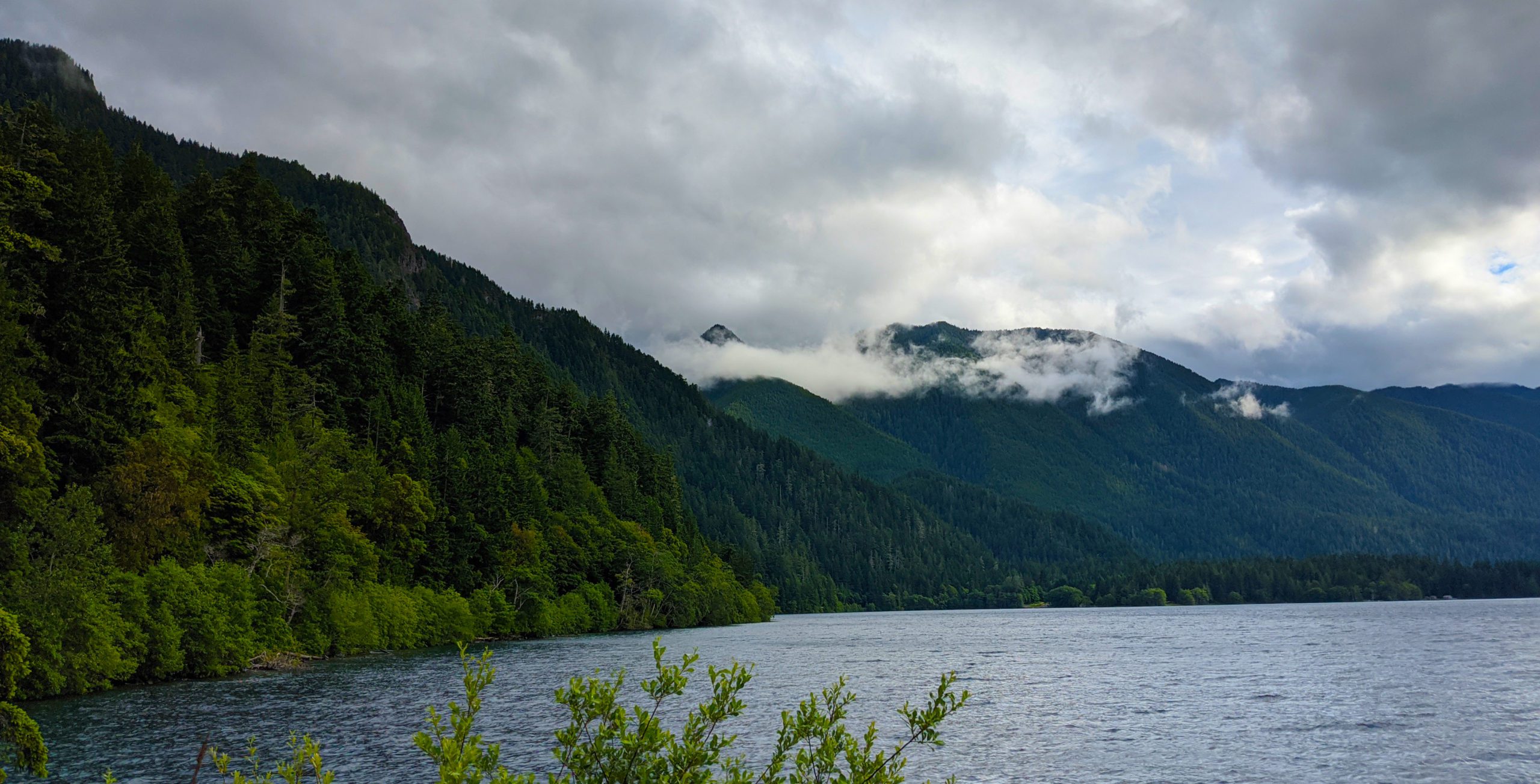
Getting back westbound on the 101, I stopped again along one of Lake Crescent’s eastern shorelines. My scouting itinerary included Storm King Ranger Station and the Lake Crescent Lodge. The stop was well worth it and I enjoyed my first views from this side of the vaunted and photogenic glacial lake.

West-facing view from Lake Crescent Lodge.

Lake Crescent is one of the clearest and deepest lakes in the state.

Lake Crescent lies entirely within ONP borders.
ADVENTURES IN CAMP-CHASING
This next part of the journey concerns those camping folk who find themselves “Camp-Chasing,” which can turn a should-be leisurely day into a stressful hunt for shelter. A primary goal of Olympic Otter is to help avoid such mishaps in planning.
With my plans of camping at Fairholme dashed, the next viable campground at Hoh Rain Forest (the one suggested by the ranger) was 81 miles (130km) distant and the sun was well on its way to setting. Still, sunset in late June is after 8pm, so I was confident I would have time to build camp before dark.

This drive takes the traveler through Forks, home of the Twilight Series
As you can see, Hoh Rain Forest presents a conundrum. There are no access roads that traverse the entire park. Each campground within the park is at the end of a “spur,” meaning there is only one way in and out.
At 18 miles (30km) the Hoh spur, which runs along the Hoh River all the way, is one of the deepest-penetrating paved roads from Hwy 101 into the ONP. By 7:30pm I reached the turnouff onto Upper Hoh Rd and was ready for camp and dinner!
When driving into Hoh late in the day, it is a very bad sign to see cars passing you in the other direction. One car might mean nothing, but on the way in I passed five vehicles, all of which were clearly loaded for camping and headed away from Hoh. Camp checkout is usually 11am and this is enforced more strictly on busy weekends. Cars departing later in the day COULD be day-hikers headed back to other abodes, but something was telling me I was headed into zero-site situation. If nothing else, my instincts were on point.
During this time of COVID, the park entrance station was unmanned, with no ranger present to tell the bad news awaiting me many more miles down the road. I arrived at the campground with the sinking feeling that my day of driving was nowhere near complete.
All three loops were full, and I dumped my theory that Hoh Rain Forest was too remote for the average Washington camper. I wasted no time getting back on 101, bound next for the blustery shores of Kalaloch.

This route finally takes drivers to the edge of the Pacific Ocean
Here is some National Park math for you: 18 miles in = 18 miles out. I faced a long and frustrating drive back to the highway.
NOW PLEASE STOP AND PAY CLOSE ATTENTION.
Vehicle-related incidents rank amongst the most frequent causes of death in national parks, and in some parks are the leader by a wide margin. These can be due to various natural factors such as inclement weather and mudslides, but are more often due to carelessness, speeding, or impaired driving. The desolate nature of some park roads leads some to drive more recklessly, especially at night. High-speed collisions with wildlife, or the avoidance of such collisions, often lead to serious incidents in areas where cellular coverage is weak and emergency medical aid is not quick to respond.
Vehicle-related incidents rank amongst the most frequent causes of death in national parks, and in some parks are the leader by a wide margin. These can be due to various natural factors such as inclement weather and mudslides, but are more often due to carelessness, speeding, or impaired driving. The desolate nature of some park roads leads some to drive more recklessly, especially at night. High-speed collisions with wildlife, or the avoidance of such collisions, often lead to serious incidents in areas where cellular coverage is weak and emergency medical aid is not quick to respond.
PLEASE DRIVE SAFELY ON NATIONAL PARK ROADS AT ALL TIMES.
Savvy to ONP Campgrounds, I knew that Kalaloch only took reservations in summer and that it would be full. I had no intention of holding out for a site, but inquiring at the Lodge I did learn that there were two open cabins.
These tiny structures are popular in the summer and on this night were renting out for around $120. I was tempted, but with a trunk full of firewood and ONP adventures in mind for the weekend, I just couldn’t bring myself to stay indoors that night.
I decided to head for Quinault.
Camp-Chasers Alert: You may use GoogleMaps here and find the next nearest ONP campground to be Queets, and this is technically true. However I had already attempted once to find it and failed. In fact, Finding Queets would become both the name of this story and the point of this trip, but it was better left for a daytime adventure.

If you’ve never been there, don’t attempt to find Queets in the dark!
My journey continued into the night, turning back eastward along the Park’s southern perimeter. With great and completely misplaced optimism, I thought I may find a campsite at Falls Creek Campground, just a little ways off the 101 and right on Lake Quinault itself. It was well after 10pm when I reached Quinault. For what it’s worth, the traveler can expect all local restaurants and stores to be long-closed by this time.
Two passes through Falls Creek’s small camping loops proved pointless; they were full-up though there were numerous unclaimed “Reserved” sites. I pushed on for North Fork/Graves Creek in the thickening blackness, now getting a little anxious that there would be no open sites awaiting.
The drive to these remote ONP campgrounds on S Shore Road runs on asphalt for only the first few miles, then degrades to dirt/gravel for the remainder, a twisting bumpy marathon hugging the Quinault River.
In the darkness I missed the left turn to North Fork, which crosses a bridge and connects with N Shore Road. No matter, North Fork Campground can be creepy in even broad daylight, and is the smallest ONP campground at only nine sites.
SETTING UP CAMP
I finally pulled into Graves Creek Campground in the witching hours – truth be told I don’t know what time I arrived. It was late, and I would be up far later, hell-bent on making a campfire and cooking a steak dinner!
Any pictures at this time would consist of near-pitch-black-darkness with the occasional glow of a dying campfire or the brief reflection of a tail lamp. The camp was nearly full, and most residents had already retired for the night.
Luckily I found a substandard-spot near the bathrooms but also near an intrepid group of campers taking it to the wee hours, and thus my late night arrival did not perturb them.
I quickly got to work unloading the necessaries to make a midnight feast on cast irons, pitching my tent, consuming the midnight feast, and stashing all foodstuffs back into my car.

Looking back on the day, I’d logged MANY more miles than originally intended. Not counting the drive from home to the Seattle ferry, the trip totaled just over 250 miles (400km) – nearly enough to encircle the ONP itself!

Tent pitched and belly full by 2:30am, I went to sleep and did NOT set an alarm.
To Be Continued…
This post is part one of a 3-part series, which you can find here as they’re published.


Recent Comments